REMEMBERING ISLIP HIGH
SCHOOL - REUNION CLASS OF 1968
Welcome
All to this Historic 50th year event.
|
|
|


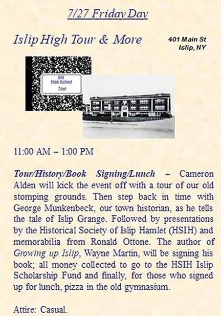 Friday 11:00, July 27th at 401 Main
Street, Islip
Friday 11:00, July 27th at 401 Main
Street, Islip
* Introduction and Tour - Cameron Alden
* Historical Society- Madeline Hanewinckel
* IHS Memorabilia - Ron Ottone
* Town Historian - George Munkenbeck
* Book Signing - 'Growing up Islip' - Wayne Martin
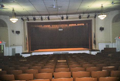
* Lunch (optional) - Pizza and soda $10 (by
reservation)
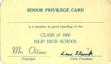
Here’s your own Senior Privilege Card if you never had
one!
Compliments of Ron Ottone.
|
|
|

The Town of Islip is named for Islip,
Northamptonshire, England. The English village of Islip was so named for a 16th
century Abbot of Westminster Abbey, named John Islip. In the 16th century, John
Islip was recognized for his great achievements, which included the
construction of a new chapel in Westminster. When William Nicoll (proper
spelling) came to the US and was granted his land patent, he named the land
after his hometown of Islip, Northamptonshire. It took FIVE patents, five
different landholders, to incorporate to create the township you see today.
Islip Hamlet was originally part of the Gibb Patent. If you visit Islip,
Northamptonshire today and notify the village of your trip, they will raise
BOTH flags in honor of your arrival. Learn more at Historical Society of Islip
Hamlet! Research: Victoria Berger
“…The greater Town of Islip had already started its
formation in 1683, as attorney William Nicoll made his first patent purchase of
the surrounding lands from the native region chief, Sachem Winnequaheagh of
Connetquot. Nicoll named his plantation Islip Grange, in honor of his family
home in Islip, Northamptonshire, England. Nicoll’s patent incorporated most of
the land surrounding the Hamlet of Islip, but excluded the land between the
creeks--- our hamlet.
In the 1690’s, Nicoll’s colleague, attorney Andrew Gibb, had come to the area
and applied for a patent of his own, for “All that tract of vacant land
commonly called by the name of Winganhauppauge or Champlin’s Creek, and on the
west by the Orowoc Creek”. He was granted his patent on March 26, 1692, from
Governor Richard Ingoldsby in the name of William and Mary, sovereigns of England.
This defined the boundaries of what was to become Islip Hamlet. Though
the Gibb Patent was a smaller, 3,500 acre tract of land, the purchase was
significant in that it was the center of commerce in the region, and developed
into both a social community, as well as the seat of the Town Government…”
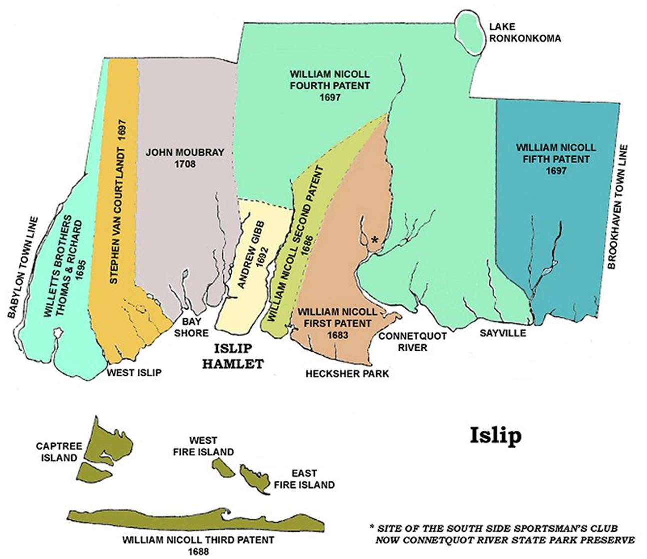
Geographic Note: The title “Between the Creeks” might
be a bit misleading to residents today, for whom the reference to Champlin and
Orowoc Creeks means the large bodies of water that appear to be located between
the Great South Bay and Montauk highway/Main Street. The head waters for those
creeks, however, are small streams that originate to the north, in the area, of
the Southern State Parkway, the service road of which is Islip Hamlet’s
northern border. (See the yellow-highlighted area of the above map labeled
"ANDREW GIBB 1692"). Research: Islip Historical Society
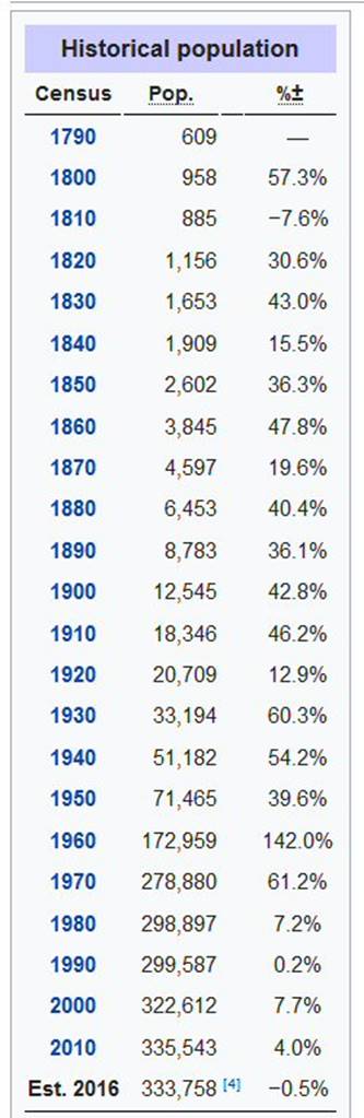 Islip Township, located on the South
Shore of Long Island in the later to be named Suffolk County, had a population
growth as the ISLIP TOWNSHIP Historical Population table left shows.
Islip Township, located on the South
Shore of Long Island in the later to be named Suffolk County, had a population
growth as the ISLIP TOWNSHIP Historical Population table left shows.
Suffolk County was one of the original thirteen
counties in colonial New York. In 1790, the first U. S. Census showed that
Suffolk County had more people than Brooklyn, Queens, the Bronx, and Staten
Island combined. Suffolk’s East End was settled earlier than its west end. The original European settlers of Suffolk
County migrated from New England communities and these early settlers were tied nationally, religiously,
culturally and politically to the communities across the Long Island
Sound. They were engaged in agricultural
pursuits and fishing, traditions that in part have continued to present day.
The eastern portion of Suffolk County was a suitable
area for early settlement because of the fertility of the soil and the
proximity bays. Through the 1800s, the
Towns of Southold and Southampton were among the most populous on Long Island.
Suffolk County only became linked socially and economically to New York City with
the development of rail transportation in the mid-1800s.
The Railroad comes to Islip – Early Depot
History:
 South Side Rail Road Depot opened: 5/20/1868
Replaced: 1881 by new LIRR Depot. Razed? (1)
2nd depot built:1881, razed: 12/1963
Track re-alignment 1906 as per Robert Emery; original Main #1 moved north, 2nd
track added 1908.
3rd depot dedication and opening: 12/7/1963 (2) North of tracks, Re-modeled
1997
1999: Hi-level platforms and shelter installed to accommodate newly arrived C3
bi-level cars which were placed in service July, 1999 Research: Dave Keller
Note
1: After the LIRR acquired the S.S.R.R. in 1880, the depot may have been razed
or moved as was known to happen at the time.
Note 2: Both the first and LIRR 2nd depot both occupied the south side of the
tracks location. The 3rd depot opening was on the current north of tracks
location.
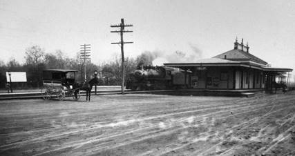 Islip 1908 view NE Collection: (Emery-SUNY Stony Brook)
Here we are at the Islip Depot as the local westbound passenger train is
just pulling in. Awaiting fares are the two horse and carriage taxis,
undoubtedly for the ride south to the Village. The new Express package House is in the
process of construction just to the east of the Depot as the volume of
shipments have been increasing yearly as Islip grows and more goods are shipped
and received daily.
You will note the ultra-rural nature
of this area as the station (approximately ½ mile from the current Islip Town
Hall) was constructed almost due east from the local LIRR station just to the
west in Bay Shore. The terrain was flat, with no grade limitations and minimal
creeks to cross: Penataquit Creek, Awixa Creek, Orowoc Creek and
Winganhauppauge Creek.
At the time, in the late 19th
Century Victorian Era, housing was typically constructed near to town, with
larger residences even on the commerce main through fares at the time; such as Main
Street (Montauk Hwy-27A). This was practical for a number of reasons; Fire
protection, access to markets, schooling of youth, time and difficultly of
travel, just for example. So, what changed all this?
New York City and Islip Connected to the World – September 8, 1910
 1st train direct from Penn Station out to Islip: 9/8/1910
It’s hard to imagine a train
arriving at a station as a major social, economic, and cultural event today.
But, the ability to rail ride directly to Manhattan (Penn Station) meant access
to economic growth and jobs. All along the Montauk Branch towns celebrated the
direct access to Penn Station from their home town. Thus, the great LIRR rail
commuter boom had begun. In addition,
easy access from New York meant growth potential for land development, housing,
investment, and growth.
Let’s look at two prominent
developers in Islip that took advantage of the LIRR to spur housing development
and population growth.
Developer: William H. Moffitt
William H. Moffitt, a real estate
developer, purchased properties further inland from the Great South Bay.
In 1906, realizing to be more successful he would need to remain closer to the
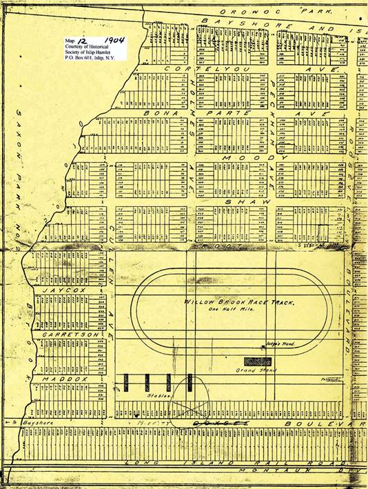
shore, Moffitt purchased what he called Willow Brook Park, Saxon Park and Olympic
Park. Willow Brook, located north of the railroad tracks in Islip was 160
acres and home to the Islip Driving Park which Moffitt later renovated into a
race track, known as the Willow Brook Driving Park. (Below right)
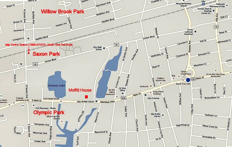
“…Moffitt
also bought himself property around Orowoc Pond, in the area north of South
Country Road between Saxon Avenue and Grant Avenue on which to build for
himself. His home, constructed of steel and concrete in 1910, was said to
have cost over $100,000 and contained 21 rooms. It was described as “one
of the most artistic and modern homes on Long Island” at that time. In
addition, he owned homes in Staten Island and Connecticut, a mansion in New
York City and property in New Jersey. That same year he became owner of the Bay
Shore Independent, a newspaper company, and a year later was elected commodore
of the Bay Shore Yacht Club.
By
1914, Moffitt was said to have been worth over $2 million and had bought and
sold over $20 million in property. He had become a distinguished
businessman whose company and accomplishments had been praised in the
papers. However, the real estate industry began to decline and Moffitt
found himself so greatly indebted he sold his home on Orowoc Pond to Walter G.
Oakman, (who in 1918 sold it to George Graham, a senior member of the U.S.
House of Representatives) in order to pay his mortgage. Moffitt was also
forced to sell a factory he owned in Bay Shore and continued to sell off his
assets for the next three years to make ends meet.
Unable to pay back creditors,
Moffitt fled to California and then became a fugitive. He had been
indicted back in New York with a grand larceny charge, as a result of real
estate deals totaling $4 million, and chose to not appear. Moffitt also
spent time hiding in London but did come back to the United States where he was
finally arrested and investigated. Eventually, Moffitt was able to pay
back his creditors and returned to California where he established another real
estate business in the 1920’s. All that was remembered of Moffitt however
back in New York was Moffitt Boulevard located in Bay Shore...” Excerpted from - "Along the Great South
Bay - From Oakdale to Babylon - The Story of a Summer Spa 1840-1940" -
Harry W. Havemeyer, 1996.
Below is Wayne Martin’s,
Class of ’68, fine compilation/research on the local neighborhood he grew up
in.

Developer:
Andrew Wolpert Sr.
In 1914, as World War I began, Andrew Wolpert
Sr., a Bavarian native who had been a real estate agent in New York City, and
his three sons began building houses in the woods between East Islip and
Central Islip State Hospital. The Wolpert's wanted to attract people of German
origin, according to historians. The place was known as Germantown, but the war
brought pressures to change the name of the community. Many people who moved
there worked in the state hospital. Info: East Islip Historical Society.
Wolpert was
President of East Islip Bank and purchased the closed Fort Upton lumber for the
construction of Germantown. That's why they were called Wolpert House's. ..."Wolpert houses, in conjunction with Suffolk County
National Bank, financed the many houses between Islip Ave.-Southern State Pkwy
(east-west) and Southern State Pkwy-Moffitt Blvd. (north-south). These were Cape
Cod style houses: basement, coal for heat, central staircase, one lower bath,
and three bedrooms upper level with detached garage. Note that interior
plumbing came into common use after WW I and the use of septic tanks. The Islip
Manor area, for example, built c.1923 and reflects the need of returning vets
for housing and the large numbers of Germans fleeing post WW I Fall 1921+ mass
starvation, inflation, and poverty. A basic Wolpert house:
Living/Kitchen/Bath/stairwell lower and three bedrooms upper connected.
As the builder can name streets; we have the
deceased wife (1905) of William Wolpert: Kunigunde Fuchs Wolpert,
later named for Kunigundia Place; the north/south street in Islip Terrace,
11752. (I was a two Summer mail carrier for the USPS). These houses were
not built en masse, as in the later Levittown production style, but all were
similar in design/layout/cost to provide entry level housing. Here’s one of our
German immigrants that had an Islip landmark right after WW II and later a
renamed mainstay:
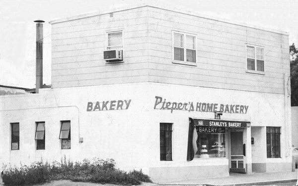 In 1948
Heinrich Pieper, who lived a couple of blocks north of Sunrise Highway east of
Islip Ave., opened his bakery. Perhaps another immigrant fleeing the
horrors of WW II and settled in the Islip Manor area. Stanley
Sadowski purchased the location in 1953 and renamed it: Stanley's Bakery.
Research: Steve Lynch
In 1948
Heinrich Pieper, who lived a couple of blocks north of Sunrise Highway east of
Islip Ave., opened his bakery. Perhaps another immigrant fleeing the
horrors of WW II and settled in the Islip Manor area. Stanley
Sadowski purchased the location in 1953 and renamed it: Stanley's Bakery.
Research: Steve Lynch
Thus, these home builders of the early 20th
Century, via the population expansion eastward from New York City, fastened by
the advent of the LIRR and availability of vast expanses of land, set the stage
for the development for the housing many of us occupied after WW I.
The growth of these neighborhoods led
directly for the need to Islip to have a larger High School to accommodate the
education of all these new arrivals children.
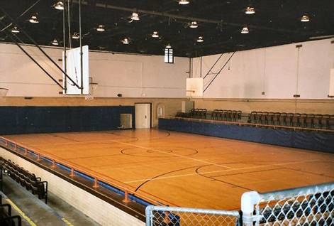
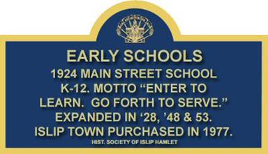
Hence, the construction and opening of the 1924
Islip High we all attended at 401 Main St. (Now the Town of Islip Public Works
building).
The
“New” High School:
After WW II the “baby boom” was in high gear.
Winganhauppauge (12/18/1953) and Sherwood (1958) Elementary
were built in the 1950’s as the increasing student population was creating
classroom pressure on the district. The ex-post office annex (directly across
and south of the Main Street High School) was called into action to handle 3
classrooms per day back in 1962 for the newly arriving 7th graders.
As a result, the following transpired:
Islip
Bulletin; October 4, 1962
Islip Votes 2-1 For New High School - But
Sinks Plans For Swimming Pool
Islip - Construction of a $4 million high
school, to accommodate 1,200 students - but without a proposed swimming pool is
expected to get underway here by next spring.
Last Saturday voters of the school district
gave two-to-one approval of the "desperately needed" high school but
swamped a separate proposition which would have provided a $268,000 swimming
pool for students' use.
The vote was 1,242 for the high school
building program to 642 in opposition.
The swimming pool proposition was handily defeated 1,137 to 777.
The district tax rate is expected to increase
from $6.91 to $7.61 per $100 of assessed valuation as the result of the vote
Saturday. Had the swimming pool been
added, another 11 cent tax rate increase loomed.
The new high school will be built on a
57-acre tract of land between Montauk Highway and Union Avenue and between
Saxton and North Ocean avenues.
At present, the district has a school
enrollment of 2,245 and by 1965, when the new high school is expected to be
occupied, the figure is expected to reach 3,200. At that time, the present high school on
Montauk Highway is slated to become an elementary school.
Next year, the district faces the likelihood
of renting facilities for some high school classes.
Only West Islip and Brentwood High Schools
have swimming pools in Suffolk County.
Numerous other districts have had propositions to provide such
facilities defeated in recent years. The
new Connetquot High School in Sayville will be equipped with a pool.
That
was Then, and this is Now:

Remember
This:
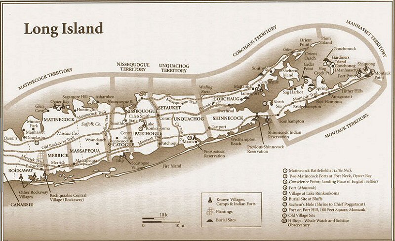
 Secatogue: A neck of land in the town of Islip and the locality
from which one of the Island tribes derives its name. It is mentioned in the
Dutch archives as early as 1639 (see Sicketen- whacky). In 1657, a Dutch vessel
was wrecked on the "South Beach" at a place called
"Secou-tagh."
Secatogue: A neck of land in the town of Islip and the locality
from which one of the Island tribes derives its name. It is mentioned in the
Dutch archives as early as 1639 (see Sicketen- whacky). In 1657, a Dutch vessel
was wrecked on the "South Beach" at a place called
"Secou-tagh."
The yearbook certainly appears aptly named!
Dates
in Time:
Sputnik One launched – October 4, 1957
Hurricane Donna landfall – September 12, 1960
Nixon debates Kennedy – September 26, 1960
John Glenn Mercury Friendship 7 Orbits the
Earth – February 20, 1962
NY Yankees Defeat SF Giants 1-0 in the final
seventh game – October 16, 1962
Cuban Missile Crisis – October 22, 1962
Assassination of President John F. Kennedy -
November 22, 1963
Beatles appear on The Ed Sullivan Show -
February 9, 1964
Northeast Blackout - November 9, 1965
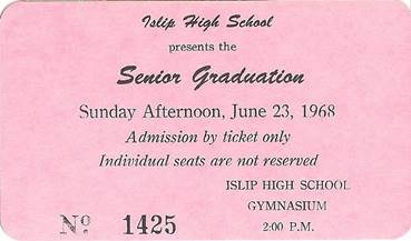
Class of 1968 Islip High Graduation
Ceremonies – June 23, 1968
Contributions:
Wayne Martin (Class of ’68): Neighborhood
Map, Growing Up Islip cover
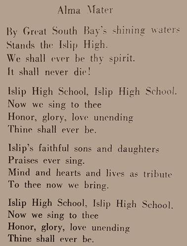
Carol Malina Liesenbein (Class of ’69): Alma Mater text from the last page of
the 1968 yearbook.
Vivian Kirkbride: Photo of Islip High School, Main St., Islip, NY 1924
Islip Historical Society, Victoria Berger: Historical Islip name background,
17th Century map and Historical Marker
Ron Ottone: 1968 Graduation Ticket, Senior Privilege Card
Steven Lynch (Class of ’69): Remembering Islip High School – Reunion Class of
1968