| RAHWAY VALLEY RAILROAD | |||||
|
|
|
Visit Richard King's website: Rahway Valley Railroad Co.
|
|||
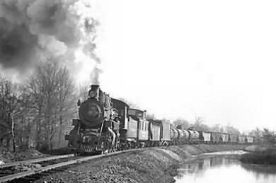
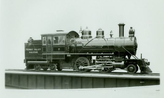
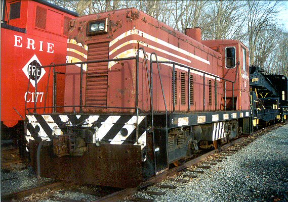
.jpg) RVRR 2-8-0 #14 - Kenilworth, NJ - 7/4/39 Baldwin: 9/1905 Serial #26356, Ex-L&NE #20 (Halsey L. Tilton photo, Dave Keller archive) |
|||||
|
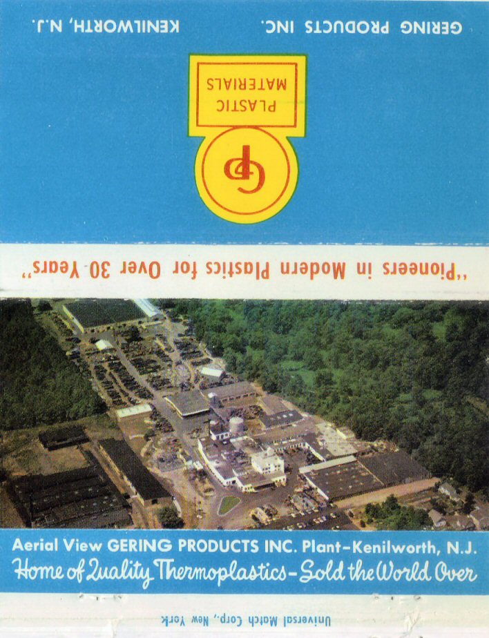
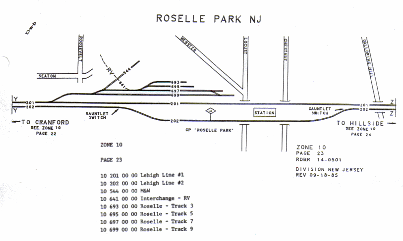
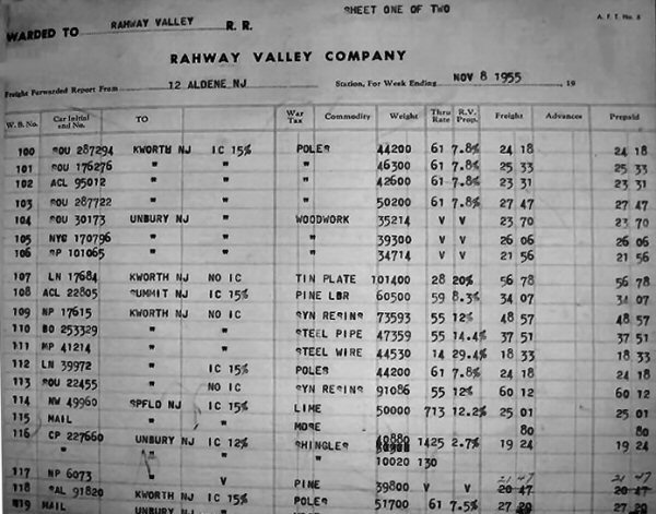
The Rahway Valley Railroad (RVRR), interchanging with the Lehigh Valley Railroad (LV) in Roselle Park and the Central Railroad of New Jersey (CNJ) in Cranford and the Delaware, Lackawanna & Western (DL&W) in Summit, NJ, was one of the most successful short lines in US history. The RVRR was able to even turn a profit during the Great Depression. During its lifetime, it was instrumental in the development of Kenilworth, site of its headquarters, as well as Union, Springfield, and other towns along its route. The railroad was created as part of an industrial development of New Orange (now Kenilworth.) The New York and New Orange Railroad extended from Aldene with the Central Railroad of New Jersey and from the Lehigh Valley is Roselle Park to New Orange, four miles. The line was foreclosed on in 1901 and was sold to the New Orange Four Junction Railroad. The NOFJ eventually went bankrupt in 1904. And was acquired in 1905 by Social Register publisher Louis Keller to provide passenger rail service to Baltusrol Golf Club, of which he was a founder. Later run as a freight-only line, the Rahway Valley was vital to industry in the area, with customers ranging from small fuel companies to Monsanto Corp. As customers switched to truck freight, moved away, or went out of business, the Rahway Valley Railroad withered to the point that service ended entirely in 1992. The primary interchange with the RVRR was at the former Lehigh Valley (LV) junction at Roselle Park. Carloads Shipped/Received decreased for example: year (cars) 1969 (1513), 1970 (1638), 1971 (1337), 1972(1005) Research: Ed Schaller |
|||||
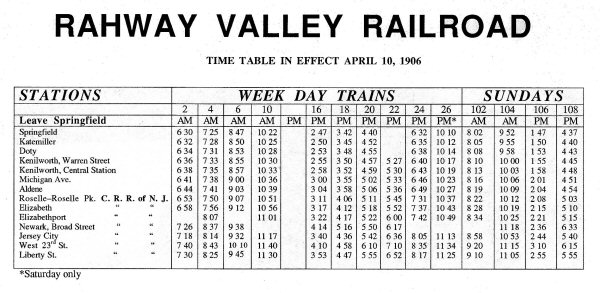 Rahway Valley Railroad Timetable 04/10/1906 Compiled/Archive: Don Maxton |
|||||
|
|
Rosters: Locations: Maps: Freight:
|
RVRR
History: Early
History: NY&NO and NOFJ 03/07/09
Photos: |
|||
|
|
Published Material:
"The little railroad that helped build Kenilworth" The
Cranford Chronicle - 5/21/211
|
||||
|
|
 |
 |
|||
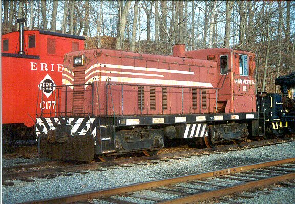
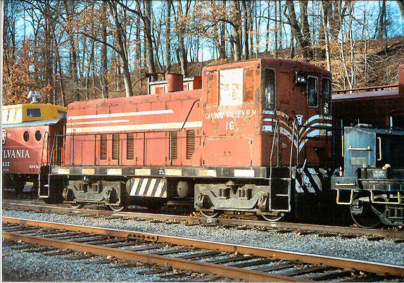
| RVRR #16 sidelined at Whippany, NJ 01/15/05 Photos: Tom Piccirillo | |||||
 |
 |
 |
 |
 |
|
|
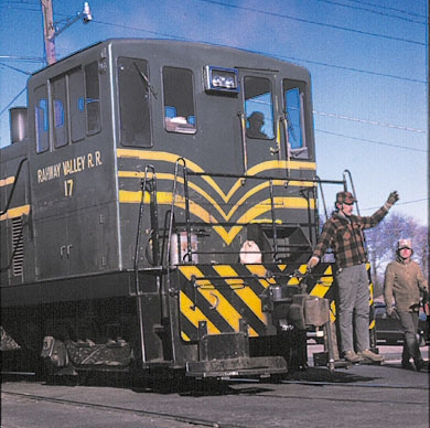
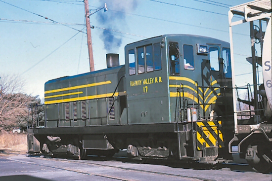
RVRR action as #17 in green livery is crossing
Kenilworth Boulevard in 1970 Photos: Tom Piccirillo |
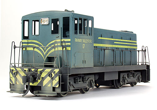
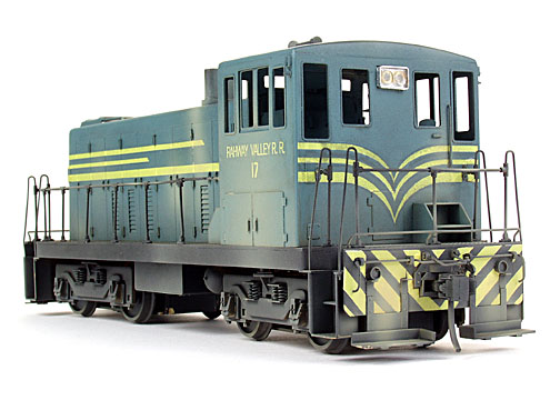
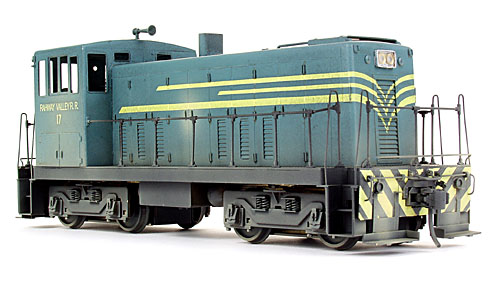
O scale model of #17 in green livery that I painted for my model railroad. The model was imported by Yoder Scale Models in 2003. The lettering was custom printed on Micro-Mark blank decal paper from artwork I produced myself. The paint was a custom blend of Floquil colors that I matched against the original color slides. 2004. Models & Photos: Tom Piccirillo | ||||
|
|
|||||
|
RVRR ABANDONMENT HISTORY |
|||||
 The DL&W interchange in Summit was the
first casualty in the post Conrail world. The last customer in Summit
was the Foster Bell plant along the Springfield / Summit border. The
plant closed in the 1980's. With its closure, the active portion of the
RV was cut back to just south of the Rahway River bridge on the
Springfield/Union border. The DL&W interchange in Summit was the
first casualty in the post Conrail world. The last customer in Summit
was the Foster Bell plant along the Springfield / Summit border. The
plant closed in the 1980's. With its closure, the active portion of the
RV was cut back to just south of the Rahway River bridge on the
Springfield/Union border.When Delaware Otsego (NYS&W) took over in 1986, the Primary interchange was moved from the LV interchange to the former CNJ interchange at Cranford (actually Aldene in CNJ days). The RV had embargoed (not abandoned) the CNJ interchange with the coming of Conrail. This track was restored by the Delaware Otsego Corp. By 1987, the RV/LV interchange was no longer used. In 1992, when service on the RV was finally discontinued, the LV connection near the Roselle Park Fire Station was ripped up and the land sold to a developer who built the homes on top of the former right of way. This forever severed the connection to the LV. (The houses next to the Firehouse were built before the the tracks were pulled up and trains were still running. The houses were built on ex-town property... Mike Cray 12/10/2001) As for the Maplewood Branch, the construction of Interstate 78 chopped the line back to Vauxhall Road in Union. Recent housing development cut the line back to Morris Avenue. Jaeger Lumber off of Morris Avenue was the last active customer north of Rt. 22 They stopped receiving cars in the late 1980's. When the State and Union County bought the property in 1994, they faced a couple of immediate problems. Two bridges along the line didn't allow 14' clearance underneath. These are the two bridge in Summit that were removed. Since it was felt that there would be no immediate need to restore this section of the line, the bridges could simply be removed and replaced "when necessary" (Read: never). At the same time the Delaware Otsego was selling the right of way to the LV so that homes could be built, they also sold the entire Monsanto Branch right of way to eager adjacent homeowners who finally got their wish of seeing the "eyesore" railroad disappear. I believe that the removal of this segment will be the one that will be most regretted in the future. All that was left is what you see today. I must say, it is horrible fate for such a once prosperous railroad. While the politicians might be successful in rebuilding some of it, I feel that commercial real estate interests will conspire to keep much of it useless..." Commentary: 5/16/2000 Eric S. Strohmeyer DID YOU KNOW #12...that the formation of Conrail in 1976 seriously hurt the Rahway Valley Railroad? In an attempt to save the many bankrupt railroads of the Northeast, the United States Federal Government formed the Consolidated Rail Corporation (Conrail) to take over these lines. Among the lines included in Conrail were the Jersey Central, the Lehigh Valley, and the Erie-Lackawanna - the RV's three interchange partners. On "C" day - April 1, 1976 - Conrail officially took over the operations of the RV's three connecting railroads. Overnight the RV's three competing interchange partners were consolidated into a single system. The RV now had three connections to a single railroad - therefore competitive shipping rates could not be maintained. In an effort to save money, Bernie Cahill (RV Pres. & GM) opted to close the ex-EL/DL&W interchange at Summit. The ex-CNJ and LV interchanges remained opened but soon all cars were routed for the ex-LV interchange at Roselle Park. The ex-CNJ interchange at Aldene was closed after a plan to utilize the ex-SIRT/CNJ interchange at Cranford Junction fell through. Confusion was the order of the day in
the early years of Conrail. "Big Blue" routed cars to the RV wherever
they wished. Once a cut of cars for Monsanto was once routed to
Summit, but Cahill refused to accept interchange. On another occasion
Conrail allowed a car to run loose down the RV all the way to
Springfield. Conrail was also tardy in picking up empties off the RV
which clogged the line with strings of empty cars ready for outbound
interchange. Many a morning Cahill would be on the phone screaming at
some "idiot" (as he called them) at the Conrail offices in Newark.
They were hurting his railroad and that was unacceptable. 3/2/2014
Richard King |
|||||
|
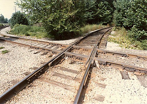
THE DIAMOND CROSSING MYSTERY SOLVED |
|||||
|
The entire
line in that area was to run at "yard speed" and that limited
them to a max of 15mph being able to stop short of any obstructions. A
switch that had about a 10 foot high switch target on it. (Note: It
was not connected to anything but the high target.) It was set one
way while the Upon throwing the switch it would show
clear to go across the diamond for the
|
|||||
|
Rahway Valley Memories: Steve Rodick c.1960's |
|||||
 RVRR freight bound home south of Route 22 entering Kenilworth, NJ Photo: William S. Young used by permission |
 Galloping Hill Golf Course, Kenilworth, NJ |
||||
|
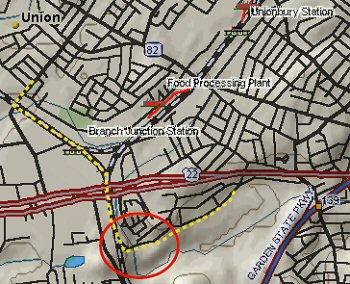
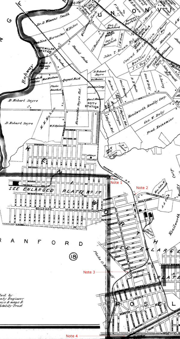
I have
circled in RED the area, I believe, that is the location of the above
locomotive photo. The yellow dashes mark the path I used to take every
weekend in order to go from my home on Liberty Ave in Union, NJ, to
Galloping Hill Golf Course, where I was a golf caddy for 5 years. It
took me onto the RVRR right-of-way that ran along "what would appear
that water area". Mind you, I caddied in the early 1960’s and
that photo goes back to the days when locomotives were running – which I
believe had to be before 1955 (I absolutely recall seeing what may have been
the last locomotive cross Liberty Avenue in that pre-1955 time frame).
As such the terrain had changed by the 1960’s – with far less water
adjacent to the tracks – but the slopes still existed – and I recall
shimmying down those every weekend! What memories. My trek each
weekend along those tracks was always an adventure – especially when I had
to cross ROUTE 22. Had my parents known I was doing that my life would
have ended as I knew it then! LOL! Also – I
recall seeing at Liberty Avenue what had to be the leftover foundation of Arion
Station or Kate Miller Station – although at the time, I thought it was
something remaining from a ramp and not an actual “station.” As it
turns out, Google maps provides a precise photo location directly on Liberty
Avenue at the intersection of the RVRR tracks. Here are both a SW and a
NW view from that Google photo location. Anecdote/Maps: Steve Rodick |
|||||
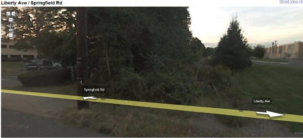 The NW view simply shows the overgrown tracks heading north with the Watchung Mountains beyond Springfield and Summit in the background; to the right is Breeze Corp. and to the left is Western Electric; (when it was there.) |
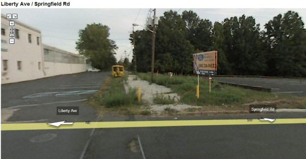 The SW photo shows the tracks and what still appears to be the “ramp” to the right, which today is adjacent to a parking lot. |
||||
|
|
|||||
 "THE
RAHWAY VALLEY RAILROAD" Donald A. Maxton
"THE
RAHWAY VALLEY RAILROAD" Donald A. Maxton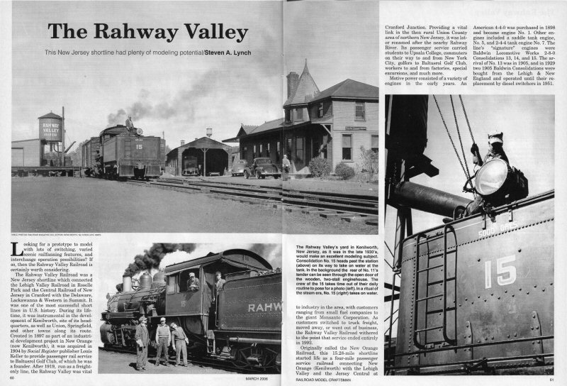